
Background
The experimental station SEM-REV (off Croisic) is situated in a zone where fields of Haploops (tube-dwelling amphipods) were listed. The sedimentary structures built by Haploops constitute a particular ecosystem which welcomes specific faunae and thus represent a potential source of biodiversity for the maritime part of the estuary of the Loire. Nevertheless, the interactions between Haploops and their environment are little known. The role of these fields of Haploops on flows (sedimentary and geochemical) as well as on the concentration of certain contaminants will be examined, by insisting on the analysis of foraminifera assemblages.
The main objective of the HOOPLA project is to estimate the potential impact of the anchoring of the wind power structures and the electric cables buried on this specific habitat and to determine the adequate indicators to follow the evolution of the disturbances engendered on the seafloor by such structures.
Scientific advances and innovation
The advances and innovations adressed within the HOOPLA project are:
- Original pluridisciplinar approaches at different spatial scales.
- New geochemical tools (2D imagery of pore water chemistry) performed for the first time in Haploops fields.
- Determination of a biotic index based on benthic foraminifera for wind power farming problematics yet non-existent.
Expected technical and economic impact
The expected impacts of the HOOPLA project are:
- Physical chemical characterization of micro-habitats colonized by Haploops
- Foraminiferal ecology description
- Temporal dynamics of Haploops fields and subsequent impact on nutrient recycling
- Impact of anchorings and partially buried cabling from the experimental station SEM-REV on this ecosystem
- Development of indexes of ecological state based on studied indicators (i.e., foraminifera and Haploops)
Key project milestones
- September 2016 - Project kickoff
- January 2018 - Haploops field mapping follow up
- January 2019 - Ecological and geochemical description
- November 2020 - Scientific publications, index elaboration, PhD thesis defense
Demonstrator
Within the HOOPLA project, the following demonstrators are used:
- Impact of embedded or buried structures from the SEM-REV station on the geographic coverage of Haploops fields.
- Comparison of foraminiferal ecology and sedimentary geochemistry between bare sediment, colonized sediment and impacted sediment.
Results
Retrouvez ici quelques grandes conclusions issues de ce projet de recherche
HAPLOOPS
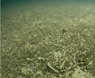
The HAPLOOPS fields are a particularly rich benthic ecosystem, allowing the development of a benthic macrofauna and a pelagic fauna.
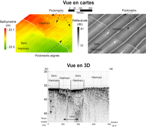 |
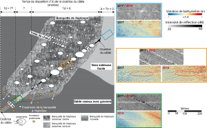
Acoustic signature of the presence of HaploopsHaploops banks appear as raised, heterogeneous and rough surfaces where subcircular depressions can be observed on the bathymetric maps (left). On acoustic backscatter sonar reflection imagery (center), Haploops banks appear darker than the adjacent sandy-muddy environments. Depending on their size, pockmarks are visible as white (muddy) disks or black dots. |
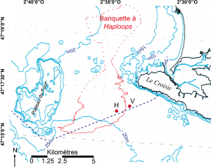 |
Mapping of the Haploops bankEstimation of the extent of the area colonized by Haploops off Le Croisic in 2018 (solid and dotted red line). This area represents about 40 km². In blue dotted line, the route of the power cable of the SEM-REV test site through the study area (thesis JB Champilou, 2020). This map was made from the compilation of acoustic data from the research vessel R/V Haliotis (Genavir – Ifremer) and required over 30 days of acquisition. |
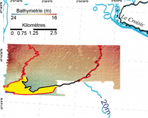 |
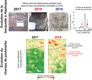
Expansion of Haploops standsThe spatial temporal dynamics of the Haploops stands between 2017 and 2018 based on the comparison of bathymetric maps seems to indicate a strong expansion of this habitat towards the southwest (yellow area) measuring about 2 km², or about 5% of the total bank area. |
|
|
Prerequisites for the establishment of Haploops standsHaploops spp. appear to require a stable support over a large area to become established consisting of either gravel (see 2017 vignette and black particle size density curve, black arrow) or tubes from previous generations of Haploops. Once settled, amphipods trap and accumulate fine particles, significantly increasing their relative proportion (red and blue particle size density curve for 2018 and 2019, red arrow). A second factor seems essential, the appearance of pockmarks. The area where their density increases the most between 2017 and 2018 corresponds globally to the area of expansion of the Haploops spp. |
FORAMINIFERAL
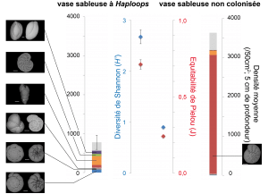 |
Foraminiferal ecologyThe foraminiferal assemblages of the Haploops mud are characterized by a higher biodiversity (H’) and a good balance (J) between major species (one color per species in the diagrams). The density of individuals is relatively low compared to the uncolonized mud. A dense, unbalanced assemblage dominated by a single species is a sign of a stressed environment. In the case of the uncolonized mud, this stress is mainly natural, linked to the variability of the discharge of the Loire and Vilaine rivers and to the physical dynamics of this coastal environment (currents, storms, tides, …). |
IMPACTS
Impact of SEM-REV’s export power cable installation on the seabed
The burial of the SEM-REV offshore test site power cable in 2012 left different marks in each sedimentary facies traversed that are fading at uneven rates. These marks can be seen on bathymetric maps and sonar imagery.
In the fluid sandy mud east of the Haploops stand, images obtained in 2017 and 2018 show no sign of the cable route (blue square). Here the ecosystem has returned to its original state in less than 4 years.
In the Haploops bench, a deep irregular trench is clearly visible in 2017 on the bathymetric map (orange square). This trench does not appear on the imagery. In 2018, some fractions of this trench appear to have been filled in (red ovals), indicating a recovery time of at least 6 years.
In the muddy sand with gravel, the cable route is visible on both imagery and bathymetric maps. In this facies, the scar is wide, straight and relatively shallow (green square). The sediment in this trench appears to be, since cable burial (2018 imagery), thinner and/or more fluid. No evidence of a return to the initial state is detectable after 7 years.
Impact study protocol: biotic indices
Biotic indices are tools that synthesize information on the quality of ecosystems in a simple way such as a numerical value that can be associated with a characteristic state of the environment. These indices are based on different taxonomic groups serving as bio-indicators. There are indices based on specific diversity, and others based on ecological groups of species.
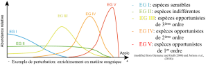
In the latter case, the assignment of species to ecological groups is based on the observation of their reactions to different environmental stresses (e.g. enrichment in organic matter, see representation above). The way in which species are assigned to each ecological group varies from one index to another, as does the way in which ecological groups are integrated into the index calculation.
Impact of export power cable installation on foraminiferal communities
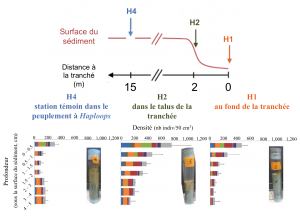
In the case of a relatively small impacted area (a few meters wide), foraminifera appear to be a suitable study tool. Indeed, a large number of individuals representing the biodiversity of the environment can be obtained by collecting a small quantity of sediment. Thanks to this characteristic, it is possible to study small ecosystems and to carry out replicates of samples in order to strengthen the subsequent statistical analyses.
In the case of the study of the cable trench, a transect was carried out from the bottom of the trench (H1), to the unimpacted Haploops spp. settlement (H4), with an intermediate point on the trench slope (H2). Three sediment cores dedicated to the analysis of foraminiferal communities were collected with scuba divers for each station. Deployment of on-board corers or grabs deployed from the deck of the ship has a localization accuracy of the order of a few square meters, making their use impossible for such a spatial approach.
Five years after the installation of the SEM-REV cable (in 2017), few differences were observed in the foraminiferal communities between the reference station and the two impacted stations. The differences are concentrated on the vertical distribution of communities and likely reflect the absence of the Haploops bench in the cable trench (see associated core photos).
Ecological status of individual stations and limitations of biotic indices
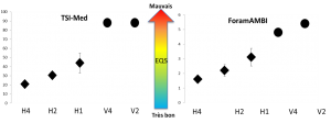
The test of two biotic indices (the Atlantic Foram-AMBI and the Mediterranean TSI), was carried out using data from foraminiferal faunas along two transects, within the Haploops bank and in the adjacent sandy mudflat.
Although the two indices do not place the stations in the same ecological states, the trends are identical:
- A broad distinction can be made between the two sites, with uncolonized sandy mud showing consistently worse results, indicative of a stressed environment.
- A decreasing gradient of ecological status can be observed between the Haploops bank and the heart of the trench, emphasizing that the trench remains an impacted environment, even after 5 years.
In order to apply these indices, it was necessary to assign some major species that were not assigned, or to modify the ecological grouping proposed in the scientific literature by taking into account our ecological observations over local assemblages.
The corrections applied to the TSI-Med do not take into account the trophic specificities of the Bay of Biscay, which biases the absolute values of the calculated ecological states. The ecology of some species still needs to be better defined for the assignment to an ecological group to be completely reliable.
GEOCHEMISTRY
Deep sedimentary geochemistry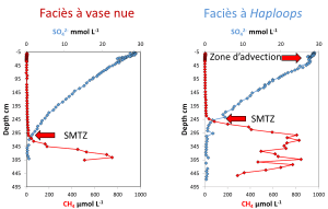
Pockmarks indicate eruptive emissions of methane into the seafloor. However, methane can also rise from its reservoir by quieter but continuous processes through the sediments by diffusion. Five meter cores from the two sedimentary facies monitored in HOOPLA show a zone of methane production closer to the surface in the Haploops and pockmarks facies than in the bare mud facies. Methane is a reduced chemical species of carbon, and when it comes into contact with the sulfate in seawater, it oxidizes and disappears fairly quickly, preventing it from diffusing into the water above the sediment. It can be noted that near the surface in the Haploops facies the vertical distribution of sulfate is disturbed and made more homogeneous than for the bare mud facies. This is due to the numerous abandoned Haploops tubes that form a layer that allows seawater to circulate thus erasing the chemical gradients within the sediment.
Surficial sediment geochemistry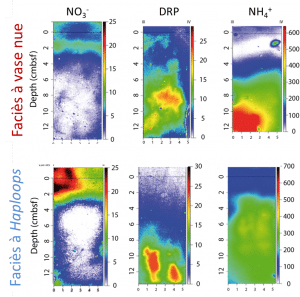
Thanks to innovative techniques (DET-2D), we are able to map the chemical compounds dissolved in the sediment at the submillimeter scale. We can therefore study in detail the effect of Haploops tube entanglement on the distribution of nitrate, phosphate and ammonium for the two facies studied. It can be observed for the Haploops sediments that phosphate and ammonium have a vertical organization that would correspond to the effect of water circulation. This translates for ammonium to less marked variations in concentration. The consequence of these circulations is the efficient oxidation of ammonium generating an excess of nitrate in the overlying water compared to the bare mud facies. This could contribute to local primary production, which would be a less ad hoc food source than the suspended of organic matter due to methane eruptions.
Publications and papers published
PhD
- 2020-“Multidisciplinary study of the Haploops spp. settlement offshore le Croisic (Loire Atlantic, French coast). Impact of a Marine Renewable Energy structure on this environment. “-Jean-Baptiste Champilou – Université d’Angers
Publications
- New evidence of perfect overlapping of Haploops and pockmarks field: Is it a coincidence?, Jean-Baptiste Champilou (Université d’Angers); Agnès Baltzer (Université de Nantes); Anne Murat (Unicaen / Cnam/Intechmer); Marine Reynaud (Centrale Nantes); Grégoire M.Maillet (Université d’Angers); Maria Pia Nardelli (Université d’Angers); Édouard Metzger (Université d’Angers), Marine Geology Volume 415, septembre 2019
Oral communications
- Toward an understanding of the gas-Haploops links through the investigation of three different hydro sedimentary environments, offshore the coast of south Brittany and Loire Atlantic (Western France): the role of pockmarks. JB. Champilou, A. Baltzer, A. Murat, M. Reynaud, A. Ehrhold, M.P. Nardelli, C. Barras, A. Mouret, F. Jorrissen, E. Metzger. 33rd IAS (International association of sedimentology) and 16th ASF (Association des Sédimentologues de France) Joint Meeting, 10-12 Oct 2017, Toulouse, France
- Foraminiferal faunas associated to Haploops spp. mats on the Atlantic French coast and effects of a wind farm installation on the area. JB. Champilou, M.P. Nardelli, C. Barras, F. Jorissen, A. Mouret, G.M.Maillet, A. Baltzer, A. Murat, JM. Rousset, M. Reynaud, E. Metzger. FORAMS 2018, 23-24 June 2018, Edinburgh
- Conditions de développement d’un écosystème dominé par Haploops spp. sous l’influence de sorties de fluides en milieu côtier. G. Gregoire, A. Murat, A. Baltzer, JB. Champilou, A. Mouret, M. Mojtahid, E. Metzger. 17ème Congrès de Sédimentologie, 21-25 octobre 2019, Beauvais.
- Two-dimensional determination of dissolved manganese in sediment porewaters with 2D-DET combined with a colorimetric method. A. Mouret, A. Barbe, R. Levrard, A. Nicol, F. Cesbron, D. Jézéquel, A. Thibault de Chanvalon, T. Jauffrais, C. Choquel, E. Metzger. 6th DGT Research Conference, 18-20 septembre 2019, Vienne.
- Apport de la sédimentologie à la détermination du potentiel bio-indicateur des espèces ingénieures : le cas des Haploops, Grégoire M. Maillet, Jacky Badelle, Jean-Baptiste Champilou, Sophie Sanchez, Maria Pia Nardelli and Edouard Metzger (LPG-BIAF-Université Nantes Angers Le Mans), 17ème congrès de sédimentologie-ASF 2019, 21 Octobre 2019
- 2D redox zonation in a sediment colonized by tube-dwelling amphipods. E. Metzger, A. Nicol, J.B. Champilou, T. Jauffrais, C. Choquel, P. Launeau, A. Mouret. Goldschmidt Conference, 18-23 août 2019, Barcelona.
- First record of foraminiferal faunas associated to Haploops settlements on the French Atlantic coast. JB. Champilou, M.P. Nardelli, C. Barras, F. Jorissen, A. Mouret, GM. Maillet, A. Baltzer, JM. Rousset, M. Reynaud, E. Metzger. Foram-Nanno, 2019, 1-4 Juillet 2019, Fribourg. Poster.
- Toward an understanding of the gas-Haploops links through the investigation of three different hydro sedimentary environments, JB. Champilou, A. Baltzer, M. Reynaud, M.P. Nardelli, Q. Dupuy, A. Nicol, C. Barras, F. Jorissen, A. Mouret, GM. Maillet, P. Launeau, A. Murat, JM. Rousset, J. Knœry, H. Roberge, E. Metzger. Oceanext 2019, 3-5 juillet 2019, Nantes. Poster.
- Methane, pockmarks and Haploops: a biogeochemical connection, E. Metzger, J.B. Champilou, A. Nicol, M. Mojtahid, C. Barras, A. Baltzer, M. Reynaud, P. Nardelli, A. Domeau, E. Bénéteau, S. Sanchez, P. Launeau, B. Deflandre, N. Briant, J. Knoery, A. Mouret, SGF 2020 – Paris, 30-31 Janvier 2020
- Space-time evolution of le Croisic Haploops settlement (Bay of Biscay), J.-B. Champilou (Université d’Angers); A. Baltzer (Université de Nantes); M. Reynaud (Centrale Nantes); Q. Dupuy (Université de Nantes); G.M. Mailler(LPG/Université d’Angers); J. Badelle (Université d’Angers); M. P. Nardelli (Université d’Angers); É. Metzger (Université d’Angers), SGF 2020 – Paris, 30-31 Janvier 2020
- Haploops settlements may be indicators of shallow pockmarks activity, A. BALTZER, JB CHAMPILOU, M. REYNAUD , JM. ROUSSET , A. MURAT, G. GREGOIRE , Q. DUPUY, P. NARDELLI, E. METZGER, A. EHRHOLD , SGF 2020 – Paris, 30-31 Janvier 2020
- First record of foraminiferal faunas associated to Haploops on the french Atlantic coasts, JB CHAMPILOU, P. NARDELLI A., A. BALTZER, C. BARRAS, F. JORISSEN, A. MOURET , G. MAILLET, JM. ROUSSET, , M. REYNAUD , E. METZGER, SGF 2020 – Paris, 30-31 Janvier 2020
For a non-specialist audience:
- La Mer XXL, exposition universelle – Exposition “Les Haploops” – 29 juin/12 juillet 2019 : Espace “Carré des Sciences” avec Centrale Nantes et l’Université de Nantes, ainsi que 2 tables rondes sur l’éolien flottant
- Exposition “Foraminifères, l’océan à la loupe” au Muséum des Sciences Naturelles d’Angers – Exposition en partenariat avec l’Université d’Angers dans le cadre du projet WEAMEC HOOPLA, du 12 novembre 2020 au 19 septembre 2021.
- FILM “Haploops & Pockmarksson”, réalisé par Quentin LETOUT & Agathe ZAVARO dans le cadre du projet HOOPLA