

Background
The SEM-REV sea test site, operated by Centrale Nantes and CNRS through the research laboratory LHEEA, outline all offshore and onshore facilities to test, with necessary operational requirements, scale one marine renewable energy demonstrators in offshore real-life conditions such as: wave energy converter, floating wind turbines and hybrid technologies. SEM-REV is equipped with in situ oceanographic instruments, electrical facilities allowing MRE devices to be connected to shore, electrical substation and communication system connected to ENEDIS network and a land based station located in Le Croisic.
One of SEMREV research activities consists in improving the expertise on the marine environment in order to acquire necessary data for environmental monitoring related to the installation of the MRE Demonstrators and to better assess potential impacts.
Floating devices (oceanographic and navigation buoy, demonstrators…) installed on SEMREV sea test site ensure their position-keeping with many equipment (anchor or mooring post) set up on the seafloor and electrical equipment (Subsea Hub, In Line Terminaison, export cable and umbilical) are also laid on the seaflour. A better understanding of SEMREV sea test site morpho-dynamics processes is necessary to assess scouring phenomenon around immersed structure and to anticipate abarasion mechanism and related risks.
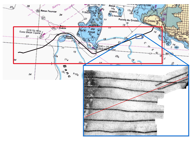
An export cable allowing to transmit electricity between the sea test site and the onshore electrical substation is embedded on almost all its way to Le Croisic. In the scope of SEMREV environnemental monitoring and to ensure that the cable would not break through the seaflour, a XYZ position tracking of the export cable has been performed with a TSS sensor and first outcomes show that the depth has changed. To ensure the embedded depth monitoring of the cable and to reduce costs related to TSS survey, ECN is willing to assess morpho-dynamics processes on course of the cable at multiple geographical and temporal scales within the Dyna-Rev project.
Scientific advances and innovation
The Dyna-Rev project aims, in the scope of a 6 months internship, to undertake a bibliography study of complex hydro-dynamics processes of the area and to carry out an analysis of morphological evolution based on the several set of data acquired by SEMREV for several years. The second objective of Dyna-Rev is to settle a hydro-sedimentary numerical model at regional scale in order to assess morphological evolution on the area highlighted as sensitive and following different scenarios
Expected technical and economic impact
This Dyna-Rev project establishes an upstream approach aimed at evaluating the environmental properties of the area in terms of morphodynamics as well as testing and advising about viable techniques for surveys of cable burial.
Key project milestones
- 04/2018 - Beginning of the project
- 09/2018 - End of the project
Demonstrator
Considering all challenges related to keep the sea test site in operational conditions, the complexity of morpho-dynamics processes of the area and the effort carried out by ECN for several years for environmental monitoring, the area represent an innovative research framework and an applicative tool to understand morpho-dynamics processes and their impact on MRE structure.
Results
- Apparent inapplicability of measurements from TSS surveys. The evolution of burial they provide is not coherent with the one inferred from historical database of bathymetric survey, as long as the cable is stable and not moving in the sediment layer.
- Coherency of bathymetric surveys, with mean accuracies in the order of magnitude of O(10cm) for the area
- Still, some specific local inaccuracies from several surveys
- Numerical tools hardly able to combine both coastal circulation and sea states as hydrodynamic forcing regarding morpho dynamic processes at intermediate depths
Publications and papers published
- Master 2 Intership Report
Prospects
This project has demonstrated the need for new development of treatment of hydrographic survey data, or for chains of sensors able to retrieve an accurate estimation of cable burial.