

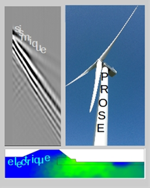
Background
The design of the wind-turbines foundations in near-offshore contexts requires the characterization of the physical parameters in sub-marine geological media, including the determination of their spatial and temporal variations. The propagation velocity of shear seismic waves is a crucial mechanical parameter for geotechnical issues. DC-Electrical resistivity is a complementary parameter that enables to discriminate between lithological layers. However, within the first 20 miles from the French Atlantic coast, the geological structures are too complex for the hypothesis of stratified medium to be considered valid. Consequently, seismic methods based on the analysis of the surface waves dispersion and the usual geo-electrical 2D-imaginig tools can not be used. To overcome this challenge the PROSE project aims to define the feasibility of seismic and DC-electrical resistivity methods able to take high spatial variations into account for imaging undersea geological media in the near-offshore area. The PROSE project is also dedicated to the development of monitoring techniques for the subsoil media in the vicinity of the wind-turbines foundations, both during their installation and their service life since the temporal evolution of the surrounding sediments is currently essentially unknown and difficult to assess.
Scientific advances and innovation
Towards a better knowledge of near-offshore geological media and their spatial variability: analysis of the potential to acquire and process geophysical data : 1) concerning seismic data acquisition carried out at sea-bottom for quantifying S velocity down to 50 m deep in the aim to overcome the inversion of surface waves phase velocity dispersion ; 2) concerning geo-electrical data, by taking the undersea environment into account to overcome the loss in sensitivity to resistivity contrasts between saturated sediments.
Towards the monitoring of undersea geological media around foundations in near-offshore context : analysis of the ability of seismic and electrical approaches to assess changes in terms of spatial and temporal resolution, and sensitivity during the installation as well as during the service life of a wind-turbine.
Expected technical and economic impact
- Feasibility of geophysical methodologies in near-offshore for characterizing the mechanical and geo-electrical parameters of the subsoil including their spatial and temporal variations.
- Decrease of the cost through a non-destructive imaging methodology by reducing the number of core drilling
Key project milestones
- September 2016 - Kick-off
- April 2018 - Go no Go before in-situ tests based on results in laboratory for the adaptation of seismic source
- January 2019 - Comparison of numerical tests and experimental results acquired at reduced scale
- September 2019 - Definition of the methodological feasibility
- Novembre 2020 - End of the project
Demonstrator
Numerical tests with the codes developed in LPG and IFSTTAR labs for the seismic and electrical (COMSOL based) approaches respectively
- experimental tests in laboratory with measurement benches adapted to reduced scales developed in the lab : GERS/GeoEND/IFSTTAR,
- Measurement tests at the SEM-REV site driven by Centrale de Nantes
Results
The different tasks of the PROSE project have been tackled in the following way :
Seismic imaging method wih a controlled source
This topic in PROSE has been tackled by a numerical approach as well as experimentally at small scale. The numerical techniques which have been developed are based on the Swarm Particles Optimization method in an original way, to reconstruct the medium parameters with a random exploration. The imaging tool shows the capacity of using surface waves for recovering the spatial variations of the S waves velocities for geological contexts of near offshore. In this way, these method allows to overcome the hypothesis of classical tools which are usually used in North Sea by assuming the medium is a successive of flat layers. The method proposed in PROSE needs measurement recorded at the seabed. In order to experimentally test this new approach, the development of an immersed experimental setup with ultrasonic transducers in a tank has been tested in laboratory. This study at small scale showed the capacity to carried out experimental data from sea-bottom with a scale ratio equal to 1/100. It reproduces the expected frequential energy content in terms of Surface Waves.
In order to propose a measurement setup available on real site, the PROSE project aims to develop a seismic source which can be put on the sea-floor and which is light enough to be moved. First tests have been done in a very shallow sea layer by using sparker source and have shown the capacity to generate surface waves in the expected frequency bandwidth. However, further tests in deeper sea level are needed for defining the faisiblilty.
DC-resistivity methods
A resistivity tomography of the subsoil allows to obtain an image displaying which areas better conduct electrical current. This kind of image then helps identifying and drawing the contours of the geological formations in the subsoil. Such tomographies are possible in marine environments too. Measurements are carried out by implementing a line of electrodes towed at the sea bottom by a vessel. However, the fact that seawater is highly conductive hampers the potential of the method. Here we aim at determining the ability of this tomography approach to help identifying the first 10 subsoil meters under about 30 to 40m of seawater. This geological setting was simplified and then simulated both by computer calculations and in a 1/100 scale model in a plastic tank in which sand and water were poured and a mini electrode line was placed at the water bottom. These simulations allowed to determine under which conditions resistivity tomography still proves relevant and what information it provides.
Seismic monitoring
Experiments have been carried out in order to establish the feasibility of the monitoring of the mechanical properties of the soil surrounding a wind turbine, by using passive seismic noise recording ; On one hand, during the stage of construction of the foundations by pile driving (analog on-shore experimental site, Gouvieux, EDF-EN), on the other hand, during the operation period (on-shore wind farm, Bouin, EDF-EN). Measurements show that, in both cases, the seismic noise generated by the pile contains suitable frequencies for the sounding and monitoring of the 10-20 first meters of the subsurface, without the need for an external seismic source.
Publications and papers published
Oral communications
- Méthode alternative d’analyse des ondes de surface, pour l’imagerie 2D du sous-sol, Pageot D., Leparoux D., Capdeville Y. and Côte P., Présentation Orale, Journées Scientifiques AGAP Qualité 2017, Paris, France, 21-23 novembre 2017
- Alternative method for surface wave inversion, Pageot D., Leparoux D., Capdeville Y. and Côte P., Présentation Orale CFA’2018, 14ème Congrès Français d’Acoustique, Le Havre, France, 23-27 Avril 2018
- Alternative surface wave analysis method for 2D near-surface imaging using particle swarm optimization, Pageot D., Leparoux D., Capdeville Y. and Côte P., Oral Presentation, Near Surface Geoscience 2018, 3eApplied Shallow Marine Geophysics Conference, Porto, Portugal, 10-12 sept 2018
- A new technique for increasing the sensitivity of marine DC-electrical resistivity acquisitions, Sérgio Palma Lopes and Philippe Côte, Near Surface Geoscience Conference & Exhibition 2020, conférence en ligne, 7-8 Décembre 2020