
Background
The technical and financial engineering of offshore renewables projects is based on the upstream availability of reliable and proven environmental data, compared to in situ measurementss. In addition, the processing of this data via documented methods and proven tools intended for technology developers provides a guarantee of quality upstream of all technology-specific calculation loops.
This RC-PLus project is backed by the European OceanERA-Net ResourceCode project winner of the 2018 call and started in 2019. ResourceCode brings together a unique consortium of specialists in hydrodynamics, modeling of environmental conditions and data processing (Ifremer, University College Dublin, University of Edinburgh, INNOSEA, OceanDataLab), associated with European test sites (SEM-REV, EMEC, SmartBay) which also collect field data and welcome developers at sea.
This project therefore constitutes an excellent opportunity to work together on the chain of analysis and processing of data from measurement and hindcast databases, specifically created to meet the description requirements associated with offshore renewables. While these databases have in the past been generated and operated in isolation, one of the advantages of this project will be to constitute a unified database and common adapted analysis tools, in order to provide a better description and improve standardization for the industry.
Scientific advances and innovation
This project aims to take advantage of the work carried out for the constitution and analysis of the HOMERE database, which is a reference in terms of high resolution hindcast database but on a small portion of European waters centered on the French Atlantic coast. HOMERE has so far provided:
- An hindcast database of high precision and resolution, centered on the sea states, with forcing coming from wind reanalyses and taking into account the tide, over 23 years;
- A tool adapted to the needs of the industry (> 50% of access requests to HOMERE come from industrial players in the offshore renewable sector);
- Data at the origin of upstream R&D work on resources and environmental conditions.
The hindcast database from RC-PLus and RESOURCECODE will provide an unique extension of HOMERE, from the south of Portugal to the north of Scotland, and will allow the project to further extend the area covered. The in-situ measurement databases made available by the partners will enrich the comparisons and validation of the models.
Beyond a simple database, to which access and operation are quickly confined to expert users, ResourceCode and RC-Plus aim to enrich the interfaces so that pre-processing and tools for first qualification, visualization and analysis can be implemented simply through an access portal users-oriented.
Expected technical and economic impact
- Development of a sea state, wind and current hindcast database, covering the Atlantic coast from Portugal to Scotland, over a period exceeding twenty years.
- Qualification of the performance of this database compared to in situ measurements from European networks and the three test sites involved in the project (SEM-REV, EMEC, SmartBay).
- Database performance greater than or equal to HOMERE in terms of description accuracy.
- Access to a visualisation tool for the generated data.
- Access to metoocean data processing and analysis tools for pre-design operation of offshore renewables projects (visualization interface, processing tools and statistical analysis, etc.).
- Implementation of an e-infrastructure for data management at sea test sites as part of the GIS Theorem, the large national hydrodynamic research infrastructure bringing together the École Centrale and Ifremer, and preparing the European solution in Marinerg-I.
- Contribution to standards development in an international committee (IEC, ITTC, etc.)
Key project milestones
- December 2019 - Kick-off meeting
- Décembre 2021 - End of the project
Results
The RESOURCECODE database
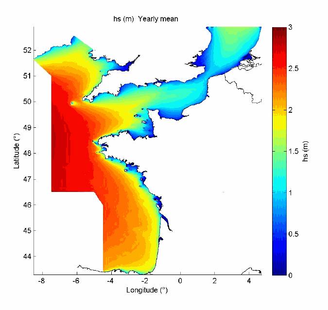
The computations to generate the ResourceCode hindcast database have been carried out by IFREMER and they cover the period from 1993 until 2020 with an hourly resolution. The database has been generated using the spectral model WaveWatch III developed by the National Oceanic and Atmospheric Administration (NOAA). For every hour, the database provides 39 metocean parameters as well as wave frequency spectra for 328,000 nodes of the model mesh, which spans from the South of Portugal to the South-West of Norway and including the Faroe Islands. Directional spectra are also available but for a subset of those nodes. The wave spectra are provided over a frequency range from 0.0339Hz to 0.91526Hz divided into 36 bins of nonuniform width. The directional spectra consist of 36 bins, 10° wide. Forcing wave fields are taken from the ERA5 database. Currents and tidal heights are also taken into account in the model.
Validation of the database
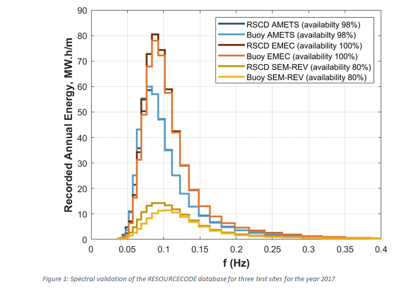
The validation of the database has been carried out using satellite altimeters data and in situ buoy measurements. The satellite data offer a wider spatial coverage than buoy data but at the expense of temporal coverage. The satellite data are taken from the CCI Seat State V1 database and the buoy data are sourced through the different European partners of the OceanERA-Net ResourceCode project. The validation is mainly focused on significant wave height but spectral validation has also been carried out at the locations where buoy data are available in spectral form, as illustrated in figure 1.
Toolbox
The RESOURCECODE toolbox offers a graphical interface to access the metocean database through a web portal and also provides a set of tools for statistical analysis and postprocessing of the data.
Through the web interface, it is possible to visualise the main integral parameters (HS, TP, etc…) as timeseries and bivariate statistical distributions.
The postprocessing tools fulfil the following functions:
- Data visualisation
- Wave resource estimation
- Extreme value analysis
- Weather window estimation
- Wave energy converter production estimates
All those tools can be downloaded as Python code, which can then be run locally. Some of those tools can also be run directly online through the web interface.
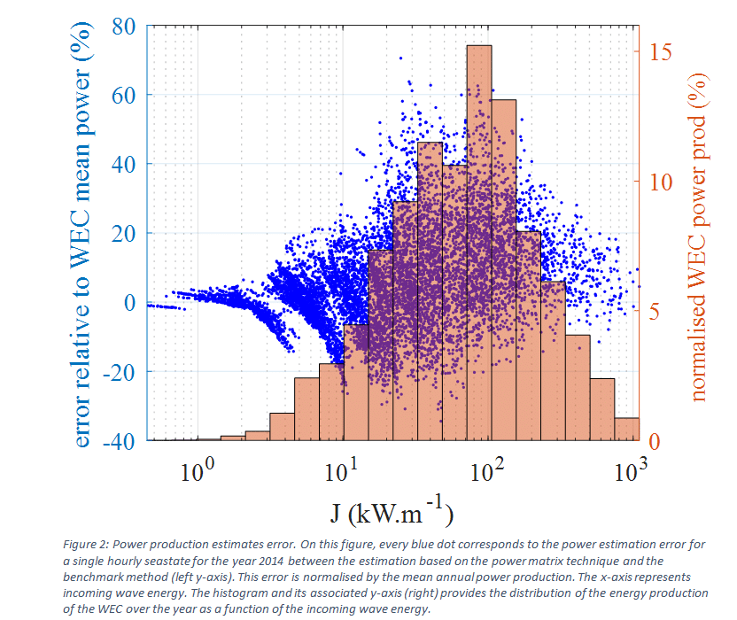
The two main contributions of the RC-plus project to RESOURCECODE are the spectral validation of the hindcast database from in situ buoy measurements and the wave energy production estimates. The latter was the focus of a more in-depth investigation looking at different techniques traditionally used to estimate energy production. More specifically, methods relying on wave resource description based on integral parameters have been compared to a benchmark approach for which the resource is characterised from wave spectra. The wave energy converter chosen for this case study is a two body heaving buoy modelled numerically in time domain. Preliminary results show that the methods based on integral parameters tend to overestimate energy production by about 6% compared with the benchmark approach for the site and year considered. However, underneath this single digit annual overestimation there are much larger overestimations (up to 70%) for certain sea states as illustrated on figure 2.
Publications and papers published
Oral communications with proceedings
- Influence of resource definition on defining a WEC optimal size. Remy Pascal, Felix Gorintin, Gregory S. Payne, David Darbinyan, and Yves Perignon. 13 th EWTEC-September 2019, Naples, Italy
- Impact of Wave Resource Characterisation on the Energy Production Estimates of Wave Energy Converters. 17èmes Journées de l’Hydrodynamique (Proceedings). 24 au 26 novembre 2020, Cherbourg, France
- Impact of Wave Resource Description on WEC Energy Production Estimates. S. Payne, R. C. R. Pascal, A. Babarit, and Yves Pérignon, in Proceedings of 14th European Wave and Tidal Energy Conference, 2021.
Article
- Satellite data for the offshore renewable energy sector: synergies and innovation opportunities. Medina-Lopez, D. McMillan, J. Lazic, E. Hart, S. Zen, A. Angeloudis, E. Bannon, J. Browell, S. Dorling, R.M. Dorrell, R. Forster, C. Old, G.S. Payne, G. Porter, A. S. Rabaneda, l, B. Sellar, E. Tapoglou, N. Trifonova, I.H. Woodhouse, A. Zampollo, Remote Sens. Environ., vol. 264, no. May, p. 112588, 2021.